Lagatar24 Desk
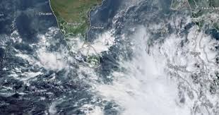
New Delhi: The India Meteorological Department (IMD) has predicted that the deep depression over the Southwest Bay of Bengal will intensify into Cyclone Fengal by Wednesday evening. While the cyclone is expected to approach the Tamil Nadu coast, it may weaken slightly before making landfall.
Cyclone Fengal’s Trajectory and Intensification
The deep depression is currently located approximately:
•110 km east of Trincomalee
•350 km southeast of Nagappattinam
•450 km southeast of Puducherry
•530 km south-southeast of Chennai
Moving north-northwestwards at a speed of 10 km/h, the system is expected to intensify into a cyclonic storm within the next six hours. It will then continue to move towards Tamil Nadu while skirting the Sri Lankan coast over the next two days.
Impact on Weather Conditions
The IMD has forecasted the following weather conditions from November 28 to 30:
•Tamil Nadu and Puducherry: Heavy to very heavy rainfall at a few places, with isolated extremely heavy rainfall.
•Coastal Andhra Pradesh: Light to moderate rainfall at many places, with isolated heavy rainfall.
•Kerala: Light to moderate rainfall at many places, with isolated heavy rainfall on November 30.
Squally winds with speeds of 55-65 km/h, gusting up to 75 km/h, are expected over the southwest Bay of Bengal and along the Sri Lankan coast. These winds may intensify to 60-70 km/h, gusting up to 80 km/h, before subsiding slightly after November 29.
Potential Risks and Preparations
Localized flooding, waterlogging in low-lying areas, and road closures, particularly in urban regions of Tamil Nadu, Puducherry, and South Andhra Pradesh, are anticipated. Authorities are closely monitoring the cyclone’s development through the DWR Karaikal radar system.
Sea Surface Temperature and Heat Potential
The system lies over a region with sea surface temperatures around 30°C, conducive to its intensification into a cyclonic storm. However, lower temperatures and reduced tropical cyclone heat potential along the coast are likely to cause marginal weakening before landfall.


